A powerful Pineapple Express storm could deliver a wet, white and potentially wild Christmas to California, with the possibility of snow in the Sierra Nevada and plenty of rainfall across the Southland.
Although the forecast is still coming into focus, the incoming atmospheric river system is shaping up to be the strongest in years to hit the Los Angeles area on the holiday — and threatens a soggy slog for those hitting the road to visit friends or family.
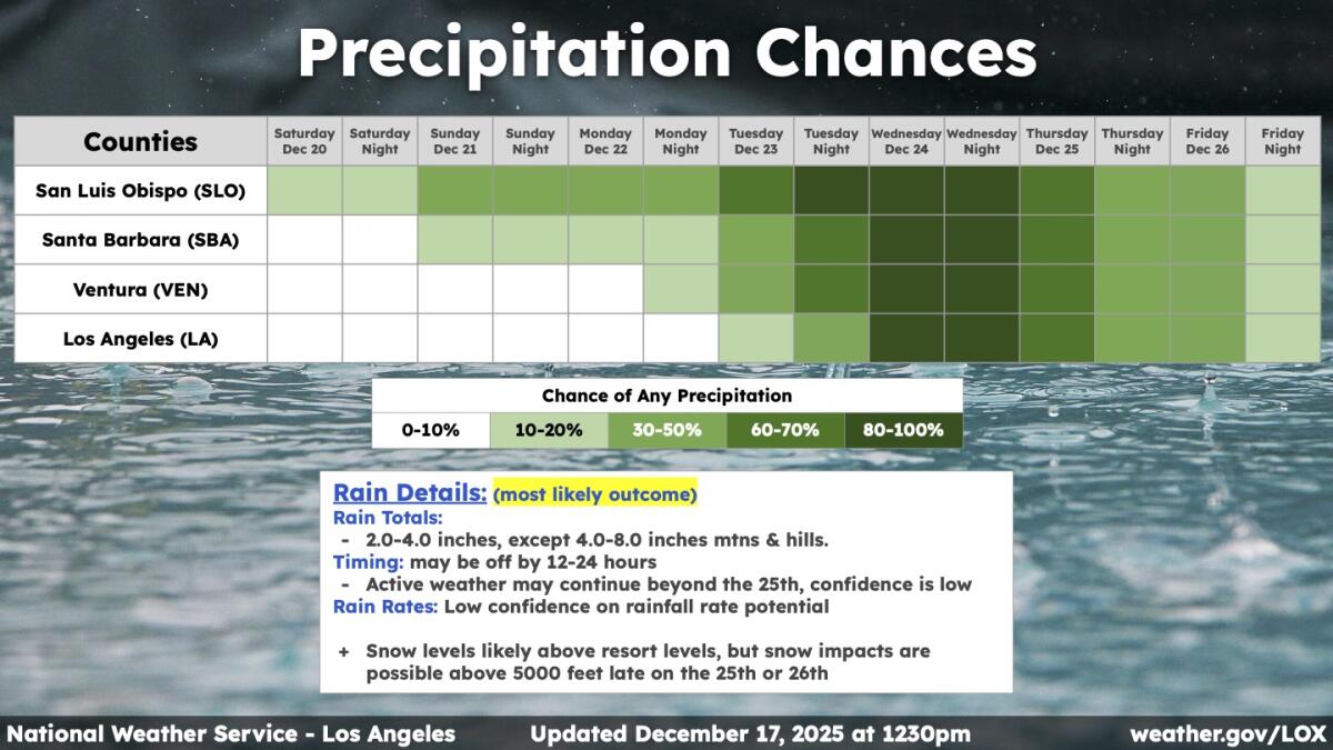
The most likely scenario for Los Angeles, Ventura, Santa Barbara and San Luis Obispo counties involves “high amounts” of rain: 2 to 4 inches on the coast and in the valleys between Dec. 24 and 26, according to Robbie Munroe, meteorologist with the National Weather Service office in Oxnard.
There’s a 50% chance of that scenario coming to pass.
There’s also a 30% chance of more moderate rainfall, 1 to 2 inches on the coast and in the valleys, as well as 10% chance of “very high” amounts, 4 or more inches, in those areas.
The last time it rained on Christmas Eve or Christmas Day in downtown L.A. was in 2021, when 0.83 inches fell over the two days. The last time it rained more than 2 inches over those two days was all the way back in 1971, according to meteorologist Bryan Lewis of the weather service’s Oxnard office.
It’s still unclear whether this storm will be naughty — with torrential downpours intense enough to cause flooding and mud or debris flows or nice, with gentle rainfall spread out beneficially over a period of days.
“Even if we see really high totals, impacts might still be more on the minor-to-moderate side,” Munroe said during a briefing Wednesday.
(National Weather Service )
But, more problematically, the Christmas week storm could turn out to be the first of a sequence, with one or even two more looming in its wake.
“This might be the first of two or three storm systems,” Munroe said. “And if that does happen, impacts could become more concerning for that period of time, possibly lasting as we close into the new year, even.”
Beyond the Christmas storm, there’s a lot of energy and moisture in the Pacific Ocean, Munroe said, “but it’s hard to know if it’s going to come in as one bigger storm or maybe two or three” more-moderate systems.
Although the storm promises to bring Southern California’s first significant soaking in a month, an interlude that followed one of the region’s wettest Novembers on record, Northern California was already hit by storms this week.
A brief lull was expected Thursday, with a parade of storms forecast to begin by that night. Localized flooding could hit the North Coast on Thursday night into Friday, while light to moderate rain was expected in San Francisco and Sacramento.
The San Francisco Bay Area is expected to see its first in a series of Christmas week storms on Sunday, potentially snarling holiday travel.
“By the beginning of next week, we are likely to see rivers begin to swell and the potential for rock and land slides to interfere with travel plans,” said the National Weather Service office in Monterey, which issues forecasts for the Bay Area.

“This atmospheric river pattern will bring significant amounts of rain,” said the weather service office in Sacramento. Snow levels could drop to 5,500 feet above sea level by Tuesday and Wednesday, suggesting “potential major mountain holiday travel impacts” for Christmas Eve.
The storm is slated to come from the tropics southwest of the California coast. It’s expected to start out as a warm storm, and some ski resorts in Los Angeles County might initially see rain instead of sought-after snow.
“There is the potential that they could get a fair amount of snow at the resort level later on Christmas Day … or into the 26th, or even beyond, if the active weather pattern continues,” Munroe said.
In the Sierra, where resorts have been pained by warm weather and a snow drought so far this season, it was far from clear whether there would be enough cold air to lower snow levels.
“This system will be drawing up copious amounts of subtropical moisture from the south,” Bryan Allegretto wrote in the weather blog Palisades Tahoe.
Allegretto said he has been nervous about the system of low pressure being too far away from California. To get more snow in California’s mountains, “we need the cold air at the center of the trough and the low to push inland,” and computer forecasting models are split on whether that will happen, he wrote.
“Let’s hope the trend is towards the storm progressing inland and dropping snow levels to the base quickly on Christmas Eve,” Allegretto wrote. “If we get the colder air, then we could see significant snowfall.”
The temperature of the storm could affect travel through key corridors. A colder storm could cause snow to accumulate on the Grapevine section of the 5 Freeway — as well as the Tehachapi Pass, which connects Bakersfield to the Mojave Desert.
In Orange County, the Inland Empire and San Diego County, the heaviest precipitation is expected later on Christmas Eve and into Christmas Day, according to the National Weather Service office in San Diego.
“But if the system stalls at all or remains further off the coast, the heaviest rainfall may be pushed back in time where precipitation may continue into next Friday or beyond,” the weather service said. “Confidence continues to increase that bouts of heavy rainfall will lead to an increased flood and debris flow risk, as well as holiday travel disruptions for the entire region.”
This story originally appeared on LA Times

